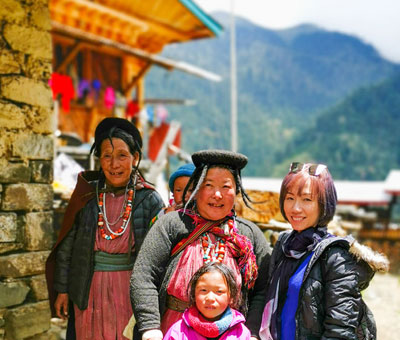
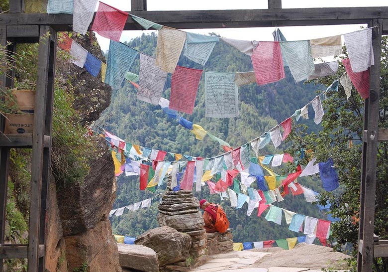
Nature in all its grandeur and unspoiled virginity is still extant in Bhutan, the dragon land. The dragon motif is inextricably woven into Bhutanese mythology and folklore and also figures in the national emblem, but the Bhutanese dragon does not spit fire. Instead its symbolizes the peaceful aspect of the country and its people.
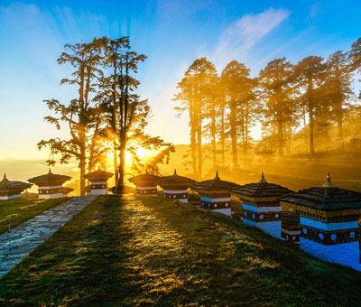
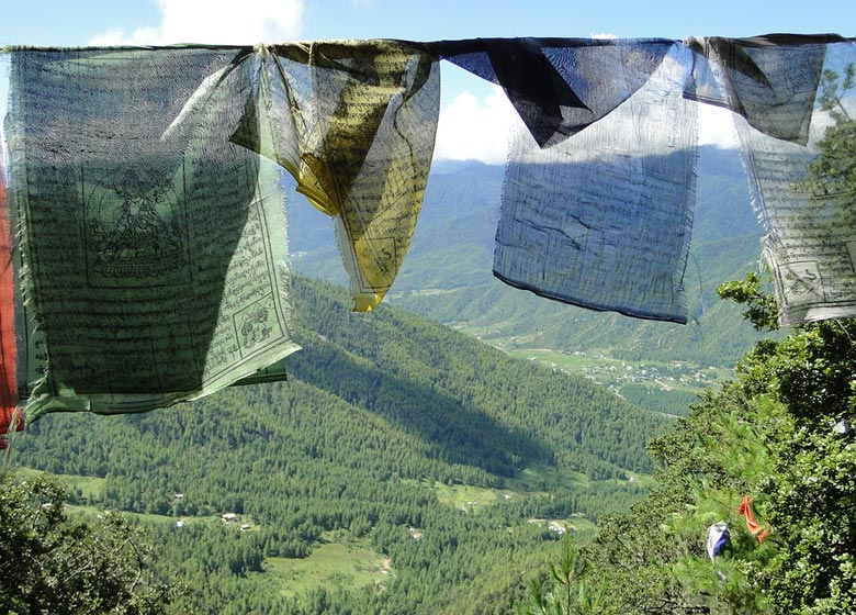
The rugged mountains and enchanting valleys, winding rivers and colorful lakes, tall shady trees and exquisite flowers make Bhutan a fascinating land and nature’s veritable paradise on earth. It is a poet’s dream come alive. A tiny speck on the world map with an area of only about 46,000 square kilometers, Bhutan has contiguous borders with Tibet, Sikkim and India. The country stretches approximately between 26°45 minutes and 28°30 minutes north latitude, and 88°45 minutes to 92°10 minutes east longitude, from the foothills skirting the plains of the India to the snow-clad eastern Himalayas towering high above. Crossing the northern half of the country one encounters a series of valleys separated by mountain ranges which are accessible only through high passes. From the foothills upward the whole country is a crisscross of valleys and ranges. This mountainous terrain naturally results in a variety of climates, from tropical to extreme cold.
Bhutan Tour Packages
Pricing and Itinerary
Bhutan Luxury Travel Packages – 04 N / 05 D
Starting – ₹ 48,000
Bhutan Honeymoon Package – 07 N / 08 D
Starting – ₹ 34,000
Wonders of Bhutan – 3 Nights – 03 N / 04 D
Starting – ₹ 18,500
Thimphu Punakha Paro Tour – 05 N / 06 D
Starting – ₹ 24,500
Best of Bhutan Tour – 07 N / 08 D
Starting – ₹ 38,500
Thimphu Paro Tour – 04 N / 05 D
Starting – ₹ 22,000
Bhutan
Bhutan can broadly be divided into four zones—northern, central, eastern and southern. Southern Bhutan consists of low foothills covered with tropical forests. The summers are warm, with torrential rains averaging 5080 mm a year. The valleys of the middle region of eastern Bhutan are comparatively narrow, between 900 and 1800 meters high. The climate varies depending upon the altitude. Though in some places the annual rainfall may be as high as 5080 mm, the aver-age is 1500 mm. Central Bhutan lies at the foot of the towering snow-clad northern mountains, with valleys at heights between 1800 and 2750 metres. With the exception of a few valleys like Punakha and Wangdiphodrang situated at comparatively lower altitudes, the other valleys, including the Thimphu valley situated at an altitude of nearly 2440 metres, are extremely cold during winter when the temperature drops to –10°C. Strong winds sweeping through the valleys make it still colder. The rainfall in the central region, however, is moderate and normally does not exceed 1000 mm a year. Northern Bhutan forms part of the Great Himalayas, its majestic ranges clothed in perennial snow, with rugged peaks rising to more than 7315 metres.
Mountain, Valleys and Rivers of Bhutan
On the north-west border of Bhutan, the 7300 meters high Chomolhari peak held sacred by the Bhutanese was successfully climbed in April 1970 by an Indo-Bhutanese mountaineering expedition. Bhutan, which is part of the Great Himalayas, the Inner Himalayas, and the foothills, has a variety of climates, and the Bhutanese in adjusting to this have become a stout and hardy people. The mountains have appreciable mineral wealth which, however, is still untapped.
Elevation and degree of monsoon exposure determine the kind and variety of vegetation which ranges from tropical to alpine. The broad-leaved heterogeneous tropical vegetation includes extremely hard, heavy and slow-growing types. The principal kinds are sal, sissoo, mixed deciduous and evergreen trees. Tall savannah grasses also abound. The temperate vegetation consists of both broad-leaved trees and conifers. The alpine zone is rich in dwarf rhododendrons and numerous other flowering plants, and has extensive pasture grounds. The flowering rhododendron trees and bushes—red, pink, white and yellow lend a festive colour to the higher landscape, and a large variety of wild orchids hang from trees in the foothills.
No less flourishing are the fruit trees of the country. Southern Bhutan is rich in citrus fruits, notably orange and lemon, as well as jack-fruit, pineapple and banana. Central Bhutan grows apple, plum, peach, pear and walnut. The valleys of Paro, Thimphu, Ha, Bumthang and Gasa, at altitudes from 1830 to 3050 metres, are ideal for developing horticulture, particularly apples, walnut, peaches, plums, apricots and almonds. In the southern foothills up to 1070 metres, pineapple, litchi, mango, orange, guava and areca nut can be grown with great success, and cardamom plantation has also been started. The developmental programmers now in progress have created an awareness of the need for scientific management of the country’s rich forests. Efforts have been made to develop these more scientifically and adopt modern methods for their management and cultivation. Forests comprise nearly 70 per cent of the total area of the country, and better forestry practices based on intensive management, education, and research rightly hold the promise of a bright economic and industrial future for the country.
Wildlife Paradise in Bhutan
Bhutan is a wildlife paradise, with its many wild animal’s tigers, leopards, wild buffalo, and bison—and the several species of deer, including the musk deer, are the poacher’s temptation. Wild tuskers find an ideal stamping ground in the country. The rare golden langur is found exclusively in Bhutan. The blue bear, which Bhutanese call dremo, has been sighted in northern Bhutan especially in Laya. It is bluish grey in colour and is a normal sized bear which occasionally walks on its hind legs. The local people have a superstitious belief that if they see a blue bear they will suffer some grave misfortune, more likely a death in the family. No wonder, therefore, they scrupulously avoid all known places of its habitation.
Another exotic species of hear known to the Bhutanese as churra is pale yellow in colour with thick long matted hair reaching down to its feet. Though ferocious in appearance, unless provoked these hears are not particularly dangerous. They live under trees with thick foliage or in caves. Accustomed to cold, they do not hibernate and are generally found at heights of 3660 meters and above. They live mainly on wild fruits, leaves, etc., but unlike other bears they are also fond of meat, especially beef. Except when they are drawn by the smell of meat they avoid human habitation, and on account of their strong smell the local people likewise avoid them.
There are two sanctuaries in Bhutan, at Manas in the south and at Laya in the north. Located on the banks of the river Manas, the Manas sanctuary is adjacent to the Assam Kamrup game sanctuary and is separated from it by the Manas River. It has an area of 182 square kilometers and is rich in wild life tuskers, buffaloes, golden langur, wild boar, pythons, tigers, bisons, rhinos and several species of deer. A tourist lodge has been built in the middle of the forest. The Laya sanctuary, till recently game preserve primarily for the king, abounds in blue sheep, musk deer, bears and different species of leopards. Pheasants are the most common birds found here.
Equally impressive is the variety of birds one comes across in Bhutan. At the foothills one finds egrets, cormorants, parakeets, woodpeckers and hornbills. Higher up live the colorful sunbirds, tits, flycatchers, and the Himalayan pheasant with its glorious feathers. The colorful butterflies that flit from flower to flower sipping their nectar are enchanting, and the Empress of Bhutan with its fascinating colours is a naturalist’s delight.
Valley of Bhutan
Valleys are all important in the economic life of Bhutan. In the extreme west of the country lies the Ha valley. With its principal settlement situated at an altitude of about 2750 meters, this valley grows wheat, barley, millet and potatoes. Yatung, an important trade centre in the Chumbi valley in Tibet, lies only two days away over the hills from Ha. Until the recent domination of’ Tibet by China, for many centuries Ha formed a busy centre of trade with Tibet, and long caravans of horses and pack-mules passing back and forth were a common sight.
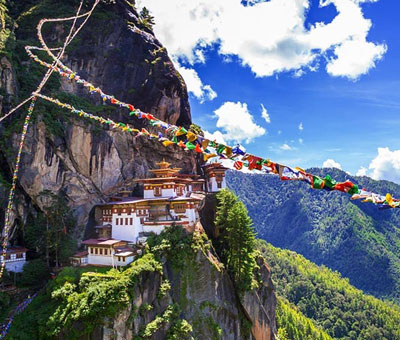
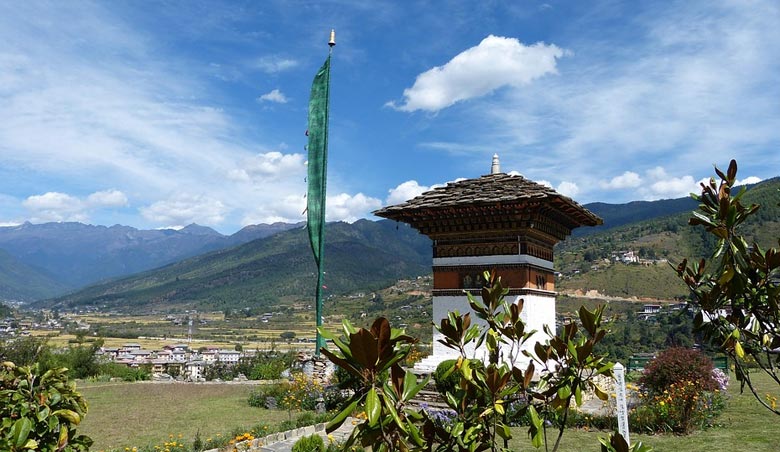
East of Ha lies the Paro valley, one of the most beautiful valleys of Bhutan and an ideal centre for tourists. It is long, wide and fertile, with the Pachu River meandering through it. The Rinpung dzong stands in the centre of the valley and lends an atmosphere of grandeur and majesty. The National Assembly used to meet in the Rinpung dzong before the new dzong at Thimphu was built. Paro boasts an air-strip, and the National Museum has been set up here. The valley has two famous monasteries which attract a large number of pilgrims every year. A magnificent view of Chomolhari peak may be enjoyed from the ruins of the Drukgyel dzong standing at the far end of the valley. The drive along the Pachu, from its confluence with the Thinchu, to Paro is an exciting experience.
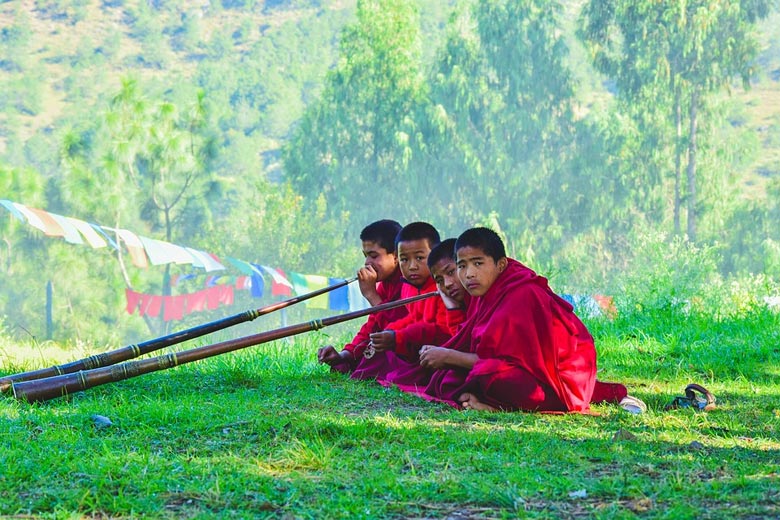
East of Paro lie the valleys of Wang district, with their headquarters at Thimphu, the capital of Bhutan. The dzong in Thimphu, except for the monastery at its centre, is a recent construction, an elegant and massive structure. Located beside the Thinchu, the dzong stands in the middle of the Thimphu valley. One is astonished to learn that this huge dzong was built by Bhutanese architects without a line drawn on paper! The dzong houses all the Ministries of the Government and is also the working place of the King. The audience hall where the King receives visitors is an imposing chamber, bright and tastefully decorated. The dzong also houses a large lamasery presided over by Je Khenpo (Chief Abbot). In the extreme north-west of Wang district, near the Tibetan border, stands the Lingshi (Long offering a magnificent view of perennial snow peaks.
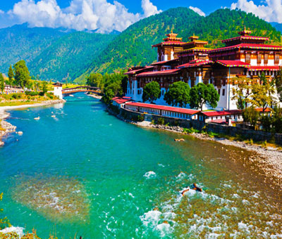
To the north-east of Thimphu lies the Punakha valley. The view of the Punakha dzong standing at the confluence of the Phochu and Mochu is truly breathtaking. Above Punakha lies the Gasa valley where herds of yaks roam the grazing grounds. Gasa is known for its butter, meat and cheese which are exchanged by the people of the region for other necessities of life. Not far away from the Gasa dzong is a famous hot-spring.
Punakha valley
South of Punakha lie the valleys of Sha district known for wide, green pastures. Even though the ranges here tower above 3660 meters, the upper reaches of the district are rich in cattle, and an experimental cheese and dairy farm has recently been set up at Gogona. The principal settlement is Wangdiphodrang situated at a lower altitude.
Eastwards from Sha district one enters the Mangde valley with the imposing Tongsa dzong standing on a ridge on the banks of the Mangdechu at its northern point. Tongsa occupies an important place in the annals and legends of Bhutan, as it was from Tongsa that the whole of eastern Bhutan was controlled for centuries. The Governor of Tongsa, Sir Ugyen Wangchuck, was elected the first hereditary King of Bhutan in 1907. The first two kings in the hereditary line ruled the country from Tongsa, but the late King Jigme Dorje Wangchuck shifted the capital to Thimphu, in the old days the summer capital of Bhutan. The lateral road which cuts across Bhutan passes through Tongsa which is also connected with Geylegphug at the foothills on the southern border. Tongsa dzong is easily the biggest and perhaps the most spectacular dzong of Bhutan. Its lamasery houses more than two hundred.
From Tongsa one passes on to the Bumthang valley the principal dzong located at Byakar, on the brow of a hill. It would be rare in any country of the world to see such broad and impressive valleys at a height of 2750 meters, and they have a special place in the heart of every Bhutanese. It was at Kurje, in Bumthang, that
Guru Padmasambhava, the great Indian saint, performed his traditionally miraculous feats. It was here, too, that Pemalingpa, accepted as an incarnation of the Guru, discovered hidden spiritual treasures from the bottom of a lake.
Still another valley, Kurto, with its dzong at Lhuntse, lies to the east of Bumthang and north-west of Tashigang. The district is well known for its woven fabrics with beautiful and intricate designs fancied by the affluent. A type of woollen cloth known as mathra is also woven in this area. The royal family has a special attachment for this district, since the great-great-grandfather of the present King belonged to a village of this district. The valley has a number of monasteries and two hot-springs. South of Kurto and west of Tashigang lies the Shongar district where the principal valley and settlement is at Mongar, which lies on the route of the lateral road and offers wide pastures for cattle.
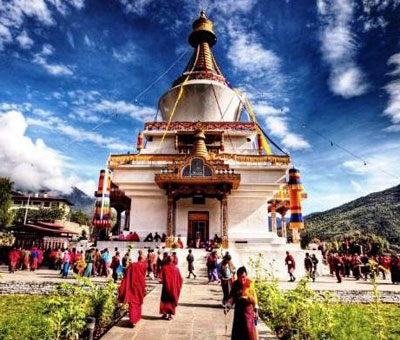
Buddhist Temple
Adjoining Kurto is the Tashigang district, the largest district of Bhutan, rich in tropical crops and fruits. Its principal settlement, Tashigang, is situated on the banks of the Dangmechu. The people of this valley still recall the old days when they used to have an extensive trade with Tibet, exchanging their rice, maize, chillies, silk and indigenous paints for salt, wool and tea. Tashigang is also known for its handloom industry. Endi silk, spun fiom cocoons bred on caster plants (as against mulberries used for pure silk), is a speciality of the place. Tashigang is connected by a metalled road to Samdrup Jongkhar on the Indian border, and is the eastern terminal of the east-west lateral highway.
To the south of Bumthang and west of Shongar lies the Kheng district with headquarters at Shemgang. The valley is famous for its handloom products but more particularly for its artistic bamboo and metal work. Dagana, a small district south of Thimphu, north of Chirang and west of Sha (headquarters at Daga dzong), is known for its thick hand-made paper manufactured from the pulp of the Daphne tree.
In addition to the above thirteen districts which cover the northern half of the country, there are two districts in the southern foothills— Samchi and Chirang. The most important place in the Samchi district is Phunt-sholing, the gateway to Bhutan. Apart from being the district headquarters, Phuntsholing is gradually emerging as a busy town with a number of small-scale industries coming up. Samchi is already an industrial town in its own way, with a distillery and a food preservation factory. The Jaldhaka Hydel Project which supplies electric power to parts of southern Bhutan is situated on the border of Samchi district.
Chirang Valley
The Chirang valley with district headquarters at Gaylegphug lies south of Dagana. This valley is thickly populated and is inhabited largely by people of Nepalese origin, who have taken to horticulture in a big way. The luscious oranges of the Chirang valley are seen in Indian markets all along the southern border of Bhutan, from Gauhati to Siliguri.
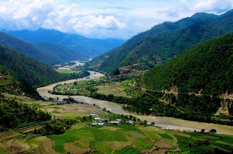
As would be expected in mountainous terrain, the country is cut by numerous rivers and streams. With the exception of two, all the rivers rise in the high snow mountains of northern Bhutan and flow south into Indian Territory where they empty themselves into the mighty Brahmaputra. The rivers provide plentiful water for irrigation in the valleys and are generally named after the valleys through which they flow, with the Bhutanese word chu, meaning stream or river, added to the name.
The Amochu, known as Torsa when it finally enters India, rises in Tibet, and the Tawangchu, which joins the Dangmechu, ultimately becoming the Manas River, rises in the mountains of Arunachal Pradesh in India. The Manas and its tributaries the Kurichu and Tawangchu —carry the largest volume of water. The Mangdechu is the western-most major tributary of the Manas and the Dangmechu is its major tributary in the east. The Manas River is navigable for about eight kilometers within Bhutan.
Pochu and Thinchu descend from the glaciers in the high mountain ranges and meet at an elevation of about 7,000 feet forming the Wangchu. The Hachu, emerging from the snow-clad ranges, flows south-east to meet the Wangchu near Chapcha, and the Wangchu ultimately enters India as the Raidak. From the snow-capped mountains above Gasa dzong raises the Mochu, which in turn joins the Pochu in the Punakha valley just a few meters from the celebrated Punakha dzong. From this point it is known as the Sankosh River. Overlooking the Sankosh, about twenty-five kilometers south of Punakha, stands the imposing Wangdiphodrang dzong.
Rivers, which in Bhutan are believed to be the abode of various spirits, especially the Naga spirits, require to be placated on occasion, but they are not considered sacred as in India. The fast flowing rivers of Bhutan are ideal sources for power generation, and plans are afoot to make the fullest use of their mighty hydel potential. One of the biggest projects to be undertaken, the Chukha project on the main highway from Phunt-sholing to Thimphu, will soon be under way to supply electricity not only to Bhutan but to adjoining parts of India as well.
The rivers abound in brown and golden trout, mahaseer and other local varieties of fish, and offer an exhilarating sport to visitors and local people, apart from helping to enrich the local diet. Flowing quietly, running in torrents, or suddenly descending over rocks in a mighty leap to the valleys, these rivers are an integral part of the splendor and enchantment of the Bhutanese landscape.
For more information on Bhutan tour packages contact Swan Tours one of the leading tour operators in India.